| Category 5 cyclone | |
|---|---|
| Category 4 cyclone | |
| |
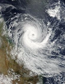
| Tropical Cyclone Larry at peak intensity on 19 March | |
| Formed | 18 March 2006 |
| Dissipated | 21 March 2006 |
| Highest winds | 10-minute sustained:
205 km/h (125 mph) 1-minute sustained: 215 km/h (135 mph) |
| Lowest pressure | 940 mbar (hPa; 27.76 inHg) |
| Fatalities | 1 total |
| Damage | $1.1 billion (2006 USD) |
| Areas affected | Far North Queensland |
| Part of the 2005–06 South Pacific cyclone season
2005-06 Australian region cyclone season | |
Severe Tropical Cyclone Larry (RSMC Nadi designation: 15F, JTWC designation: 17P) was a tropical cyclone that made landfall in Australia during the 2005-06 Southern Hemisphere tropical cyclone season. Larry originated as a low pressure system over the eastern Coral Sea on 16 March and was monitored by the Australian Bureau of Meteorology in Brisbane, Australia. The low-pressure area formed into a tropical cyclone two days later and quickly strengthened into a Category 5 storm on the Australian tropical cyclone scale. Larry made landfall in Far North Queensland close to Innisfail on 20 March as a Category 4 with wind gusts reaching 240 kilometres per hour (150 mph) and dissipated over land soon after.Throughout Queensland, Cyclone Larry resulted in roughly A$1.5 billion ($1.1 billion USD) in damage. At the time, this made Larry the costliest tropical cyclone to ever impact Australia; surpassing Cyclone Tracy in 1974, (not accounting for inflation).
Meteorological history[]
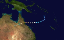
Storm Path.
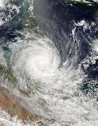
Larry making landfall on Queensland coast.

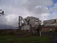
The Mourilyan sugar mill after the cyclone.
Larry began as a low pressure system over the eastern Coral Sea that was monitored by the Australian Bureau of Meteorology from 16 March 2006. It formed into a tropical cyclone 1,150 kilometres (710 mi) off the coast of Queensland, Australia on Saturday 18 March 2006. Larry was a Category 2 cyclone in the Australian intensity scale when the cyclone watch commenced, and gradually intensified to a high Category 4 on that scale. The eye of Larry crossed the coast near Innisfail between 6:20am and 7:20am AEST on 20 March. According to preliminary data, the winds near Innisfail may have reached 290 kilometres per hour (180 mph) with gusts to 310–320 kilometres per hour (190–200 mph). However, re-analysis based on land observations indicated that Cyclone Larry was a Category 4 cyclone during landfall, as wind gusts were estimated to have reached 240 kilometres per hour (150 mph) in the area of impact. A month later, Cyclone Monica crossed the Queensland coast.
The Australian intensity scale is based on maximum wind gusts, which are estimated to be 40 percent above 10-minute sustained winds. On this scale, Larry peaked as a Category 5 cyclone. On the Saffir-Simpson Hurricane Scale, the Joint Typhoon Warning Center's maximum 1-minute wind speed assigned to the cyclone define it as a Category 4 storm.
Based on estimated winds speeds required to destroy simple structures, a damage survey of buildings in the Innisfail region estimated peak gust wind speeds (in reference to flat open country at a height of 10 metres (33 ft)across the study area to range from 180 to 230 kilometres per hour (110 to 140 mph). This estimate correlates with the Bureau of Meteorology's re-analysis of Cyclone Larry at landfall. Their reviews of data suggest that Larry was a Category 4 system when it crossed the coast. It was confirmed by the Bureau of Meteorology in March 2007 that the cyclone made landfall as a Category 4 cyclone.
A 10-minute average wind speed of 108 knots (200 km/h; 124 mph) was reported in Innisfail during landfall, theoretically corresponding to 1-minute sustained winds of 125 knots (232 km/h; 144 mph), and maximum wind gusts generally consistent with a Saffir-Simpson scale Category 4 storm. At 1 am AEST on 21 March, Larry was downgraded to a Tropical Low pressure system as it moved inland. Ex-tropical cyclone Larry was further tracked as it moved into western Queensland to the north of Mount Isa. Larry's short life as a cyclone is attributed to its speed; the system moved very quickly over the Coral Sea dissipating nearly 24 hours after landfall. Cyclone Larry was considered to be the worst cyclone to hit the coast of Queensland since 1931, until it was surpassed by Cyclone Yasi in 2011; consequently, the name "Larry" was retired on December 12, 2006.
Impact[]

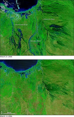
False-color image showing the extent of flooding in the area around Normanton and Karumba, Queensland. Green indicates vegetation and blue indicates water. The top image is two weeks after the bottom.
Cyclone Larry was regarded as the most powerful cyclone to affect Queensland in almost a century. According to Queensland state Counter Disaster Rescue Services executive director Frank Pagano, Cyclone Larry constituted "the most devastating cyclone that we could potentially see on the east coast of Queensland for decades ... there was great destruction." Then-Premier of Queensland, Peter Beattie declared Larry a disaster situation, comparing it to Cyclone Tracy, giving local governments the authority to enforce mandatory evacuations.
The then Australian Prime Minister John Howard said of Larry, "this cyclone is of an enormous magnitude" and reserved several UH-60 Black Hawk and CH-47 Chinook heavy lift helicopters for rescue efforts in the aftermath of the cyclone. He also promised grants of $10,000 to businesses affected by the cyclone.
An appeal fund was launched by the Queensland Government, with an initial donation of $100,000; the Commonwealth Bank initially donated $50,000, and then increased its contribution to $1 Million after examining the devastation. Premier Beattie asked "everyone to dig deep and help people who have suffered in the devastation wreaked by the cyclone."
Cairns airport and harbour were closed, and all flights were suspended. Innisfail, where Larry made landfall, suffered severe damage. In Babinda, 30 kilometres (19 mi) north of Innisfail, up to 80% of buildings were damaged. The region's banana industry, which employs up to 6000 people suffered extreme losses of crops, accounting for more than 80% of Australia's total banana crop. The Atherton Tablelands also received a great deal of damage from Cyclone Larry, with damage to buildings, and major disruptions to power, water and telephone services.
Other towns suffering damage included Silkwood (99% of homes damaged), Kurrimine Beach (30% of homes damaged), and Mission Beach (30% of homes damaged). Cairns, the largest city in the region affected by the cyclone, sustained minor structural damage, mostly comprising fallen power lines and houses damaged by fallen trees throughout the city. Light aircraft were flipped over at Cairns Airport.
A damage survey of buildings in the Innisfail region concluded that the majority of contemporary houses remained structurally intact, though many roller doors were destroyed. The report noted that the structures should have been able to withstand the cyclone, as the winds impacting the buildings were below the threshold required for meeting the region's building standards. Buildings constructed prior to the introduction of higher cyclone rating standards suffered comparatively more damage. In total 10,000 homes were damaged.
Preliminary reports estimated the cost of loss and damage to domestic and commercial premises is to be in excess of half a billion dollars.
After landfall, Tropical Cyclone Larry moved over north-western Queensland on 22–23 March, with heavy rain falls across the region. Gereta Station, north of Mount Isa, recorded 583 mm of rain in the 48 hours to 9 am on 23 March. Heavy flooding was reported along the Leichhardt River downstream, resulting in the inundation of some cattle properties.
Aftermath[]

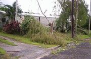
Photo taken by a resident in Edmonton, an outer suburb of Cairns in the aftermath of the storm, on 20 March 2006.
The then Governor General of Australia, Michael Jeffery, visited the area several days into the recovery, met with groups of people on the ground, and viewed the devastation from the air.
Australian Defence Force []
A few hours after the immediate effects of the cyclone, the Australian Defence Force dispatched elements of the Townsville based 3rd Brigade and the Cairns based 51st Battalion, Far North Queensland Regiment, Royal Australian Navy and the Royal Australian Air Force including: six Black Hawk helicopters, three Iroquois helicopters, one Chinook helicopter, one Seahawk helicopter, three Navy Balikpapan class LCH Landing Craft, two Caribou aircraft, two C-130 Hercules, and several LARC-V amphibious 4WD vehicles.
A Combat Services Support Battalion coordinated emergency support at Innisfail Showgrounds, providing health care, environmental advice, fresh food and purified water (as well as testing local supplies), tarpaulins, bath and shower facilities, and up to 500 beds.
QLD Rural Fire Service (Thuringowa Group) []
Thuringowa Group Rural Fire Brigade volunteers responded immediately after the impact of the cyclone. The rural fire volunteer task force set up a command post at East Palmerston, which was in place for a number of weeks. A newly acquired Emergency Support Unit was quickly prepared for disaster relief operations.
Leadership by General Peter Cosgrove []
Former Chief of the Defence Force, General Peter Cosgrove, took charge of recovery efforts, and was directing activities from Innisfail by 24 March. He called for an economic assessment by state and federal governments, and specified a moratorium on businesses' debt repayments to banks for 3 months.
Tradesmen and prisoners []
About 150 tradesmen from around Australia arrived in Innisfail around 26 March, and worked to reopen schools and other public buildings, and to make private dwellings habitable.
The Queensland Government also investigated how many trusted prisoners could be organised for work-gangs.
Accommodation []
Media outlets reported that rental agents were working to find accommodation for displaced persons, after the already tight accommodation market was exacerbated by the severe damage done to homes in the affected areas. Many tenants and owners of severely damaged homes had little chance of finding accommodation in the area, and many were expected to move to Cairns for several months. Many people were sheltered in town halls while the defense force built additional temporary accommodation.
Banana Shortage []
The cyclone destroyed 80–90% of Australia's banana crop. Australia is relatively free of banana pests and diseases, and therefore does not allow bananas to be imported. Bananas were in short supply throughout Australia for the remainder of 2006, which increased prices across the country by 400–500%.